
Integrated Approach to Slope Monitoring: Combining Satellite and Drone Technologies for Proactive Risk Management
Introduction
Geological and geotechnical risk management is of paramount importance in regions characterized by complex topography and subject to extreme climatic phenomena. In this context, the use of advanced technologies for slope monitoring proves crucial in preventing landslides and soil movements that could endanger infrastructure and human lives.
Innovative Methodology: A Two-Phase Approach
Phase 1: Historical Analysis through Satellite Interferometry
The first step in slope analysis consists of using satellite interferometry to create a retroactive history of ground movements. This technique, based on the analysis of radar images acquired by orbiting satellites, allows for:
- Identification of areas subject to deformation over the years
- Quantification of ground displacement rates with millimetric precision
- Efficient and non-invasive mapping of vast areas
Satellite interferometry provides an overview of long-term movement trends, allowing the identification of the most critical zones that require more in-depth monitoring.
Phase 2: Detailed Surveys Using Drones
Once the areas of greatest interest have been identified, drones are employed to conduct high-resolution surveys. The advantages of this technology include:
- Generation of extremely detailed three-dimensional point clouds
- Possibility of conducting repeated surveys over time with high frequency
- Access to impervious or dangerous areas without risks to operators
The point clouds obtained from drone surveys can be compared over time, allowing for:
- Detection of even minimal changes in slope morphology
- Calculation of volumes of displaced or eroded material
- Identification of potential local instabilities not visible from satellite images
Data Integration and Prediction of Future Developments
The true power of this approach lies in the integration of data from the two phases:
- Historical data obtained from satellite interferometry provide long-term context and help identify large-scale movement patterns.
- Detailed surveys carried out with drones offer a high-resolution view of current conditions and recent changes.
By combining this information, experts can:
- Develop more accurate predictive models on the future evolution of slopes
- Identify early signals of potential instabilities
- Plan targeted consolidation or risk mitigation interventions
Considerations
The integrated approach that combines satellite interferometry and drone surveys represents a qualitative leap in geological and geotechnical risk management. This methodology not only allows for effective monitoring of vast areas of territory but also provides tools for proactive risk management, enabling intervention before catastrophic events occur.
In regions where ground stability is crucial for the safety of infrastructure and communities, the adoption of these advanced technologies is a fundamental investment for a safer and more resilient future.
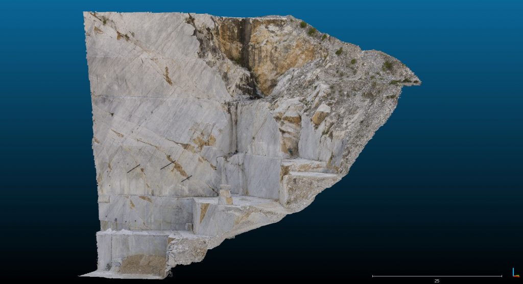
Case Studies in Advanced Photogrammetry and 3D Modeling
To illustrate the power and versatility of modern photogrammetry and 3D modeling techniques in geological and structural analysis, consider the following examples:
Seceda: Digital Twin of a Dolomite Rock Face
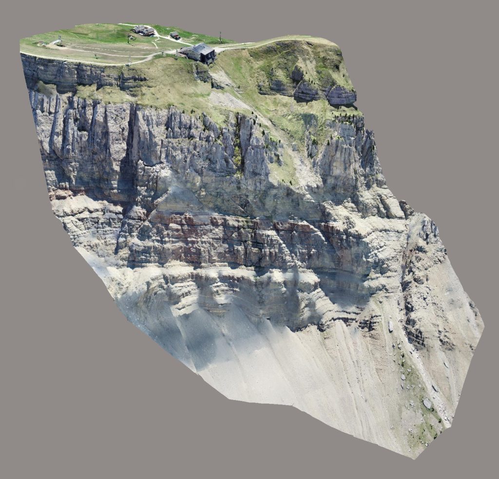
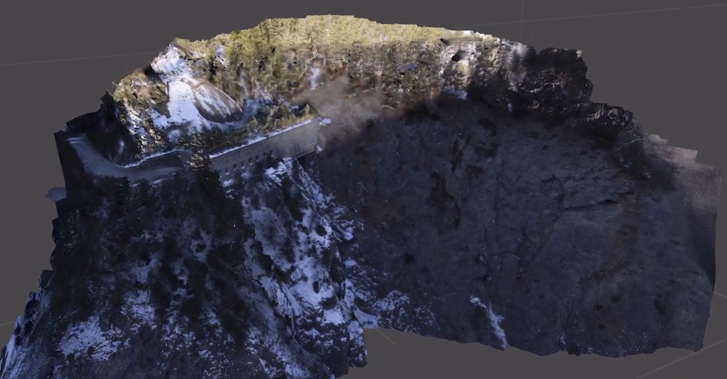
In the Dolomites, a digital twin of a rocky ridge was created to assess and ensure the safety of certain areas. This project mirrors the challenges of slope monitoring, as it deals with steep, potentially unstable terrain. The resulting 3D model was instrumental in designing rockfall retention structures, addressing a common hazard in the Dolomites and similar mountainous regions. This case demonstrates how detailed digital models can directly inform safety measures in geologically complex areas.
Sanctuary: Cliff-Face Structural Analysis
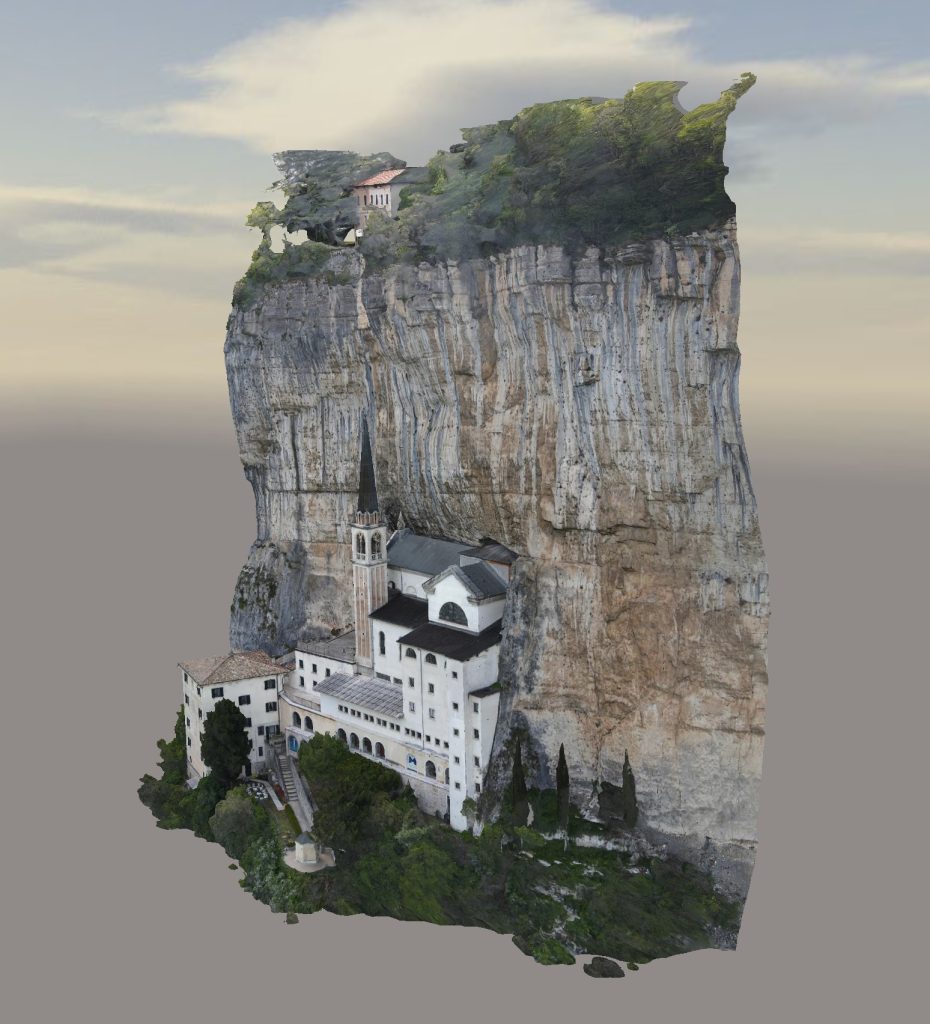
A unique project involved creating a digital twin of a sanctuary embedded in a vertical cliff face. This scenario closely parallels slope monitoring challenges, combining natural geological features with man-made structures. The resulting model showcases the value of digital twins in analyzing both natural formations and architectural elements in precarious locations. Such models are crucial for assessing structural integrity and planning conservation efforts in challenging environments.
Gardena Pass: Integrated Geological and Infrastructure Assessment


The Gardena Pass project exemplifies a comprehensive approach to slope and infrastructure monitoring. Beyond creating a detailed 3D model of the mountainous terrain and the road leading to the pass, this project incorporated geoelectric surveys to detect underground water sources that could compromise the stability of both the mountain slope and the road. This multi-faceted approach illustrates how combining various survey methods can provide a more complete picture of potential geological hazards.
Luxury Hotel: Multi-dimensional Surveying
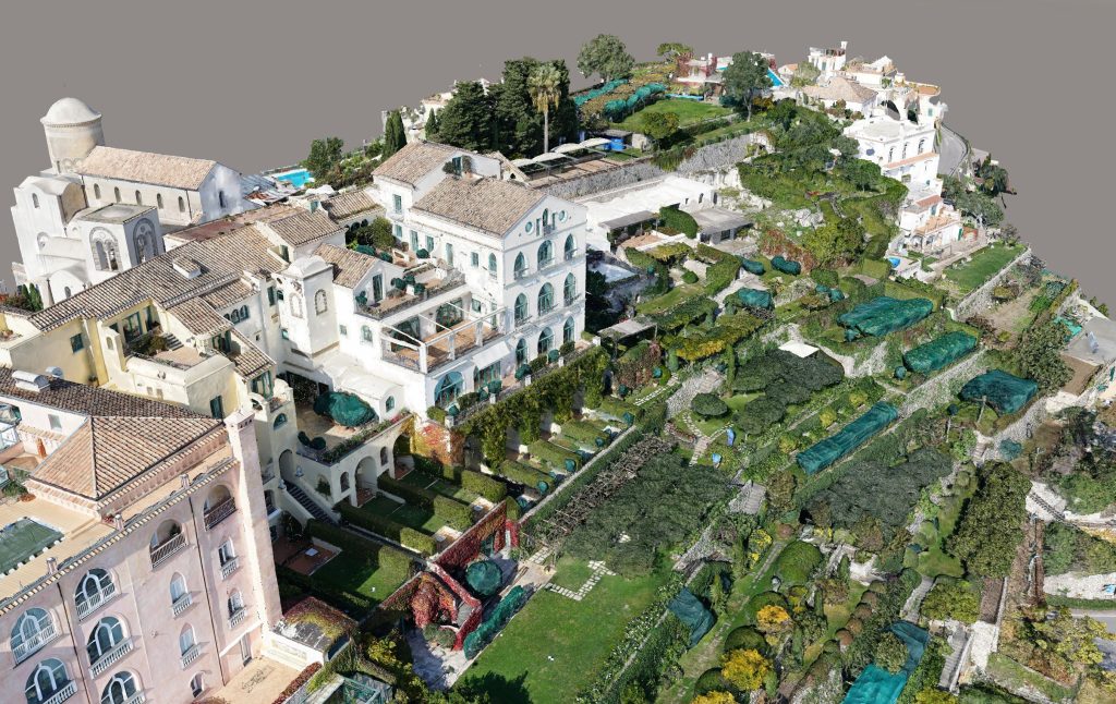
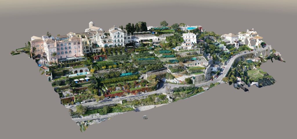 While not directly related to slope monitoring, a project involving a 5-star hotel demonstrates the versatility of modern surveying techniques. This comprehensive survey combined interior laser scanning, exterior photogrammetry, and ground-penetrating radar for archaeological investigations. Such a multi-pronged approach showcases the ability to integrate various data types – exterior, interior, and subsurface – into a cohesive model, a skill that’s equally valuable in complex geological assessments.
Cathedral: High-Detail Modeling of Complex Structures
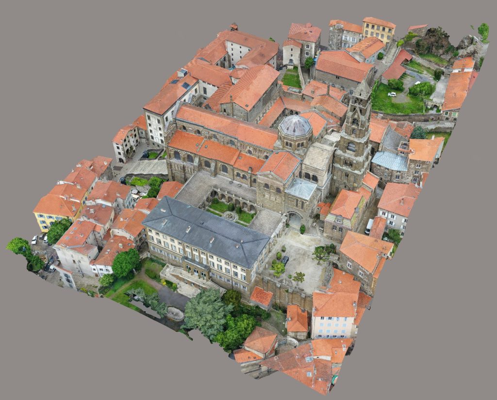
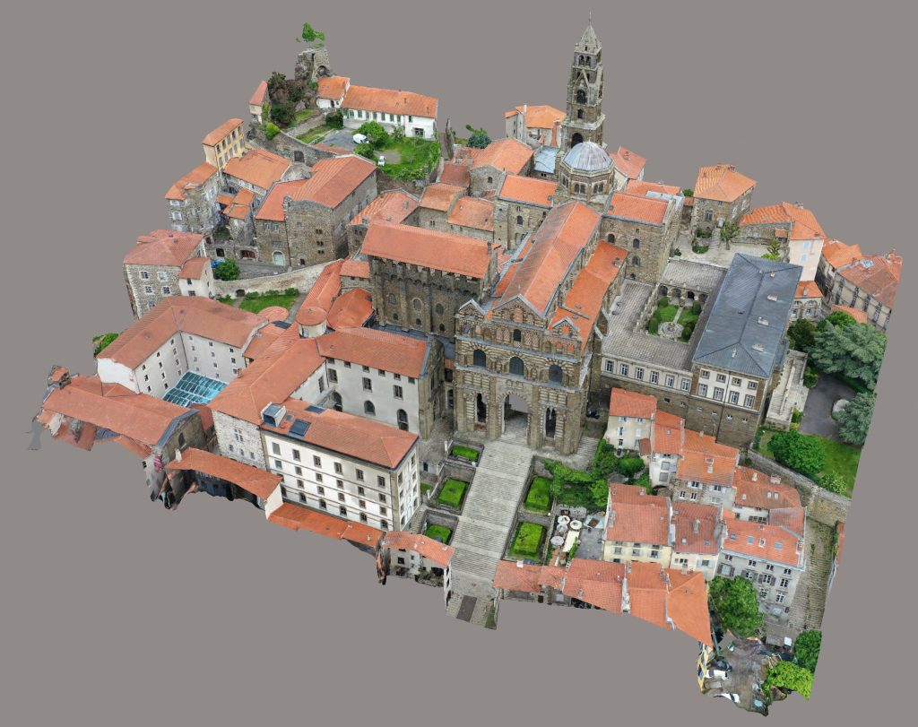 The creation of a highly detailed digital twin of a cathedral, while not related to slope monitoring, demonstrates the capability to accurately model intricate structures. This expertise in capturing fine details and complex geometries is directly applicable to geological surveys, where precise representation of rock formations, fracture patterns, and subtle surface changes is crucial for accurate risk assessment.
Treatise on the Extraction and Analysis of Sections from Point Clouds: Applications in Geology and Geotechnics
The integration of point clouds with analysis softwares and AI is revolutionizing geological and geotechnical study and monitoring methods. This approach allows for the creation of high-resolution three-dimensional models that can be used for various applications, from geological characterization to slope stability analysis, and deformation monitoring. The ability to create digital twins of slopes, which can be updated over time and used for simulations and predictive analyses, represents a significant advancement in proactive geological risk management.
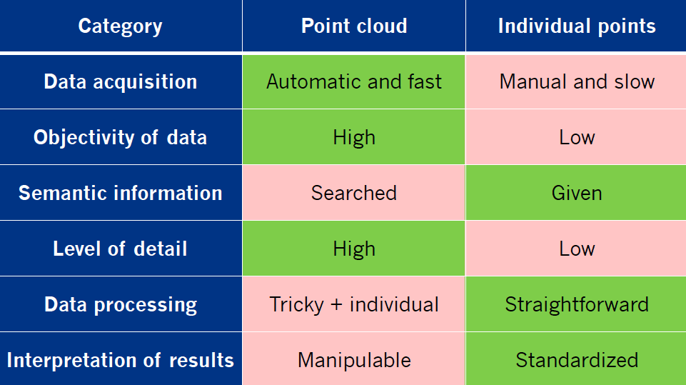

Individual points
Pointcloud (with RGB)
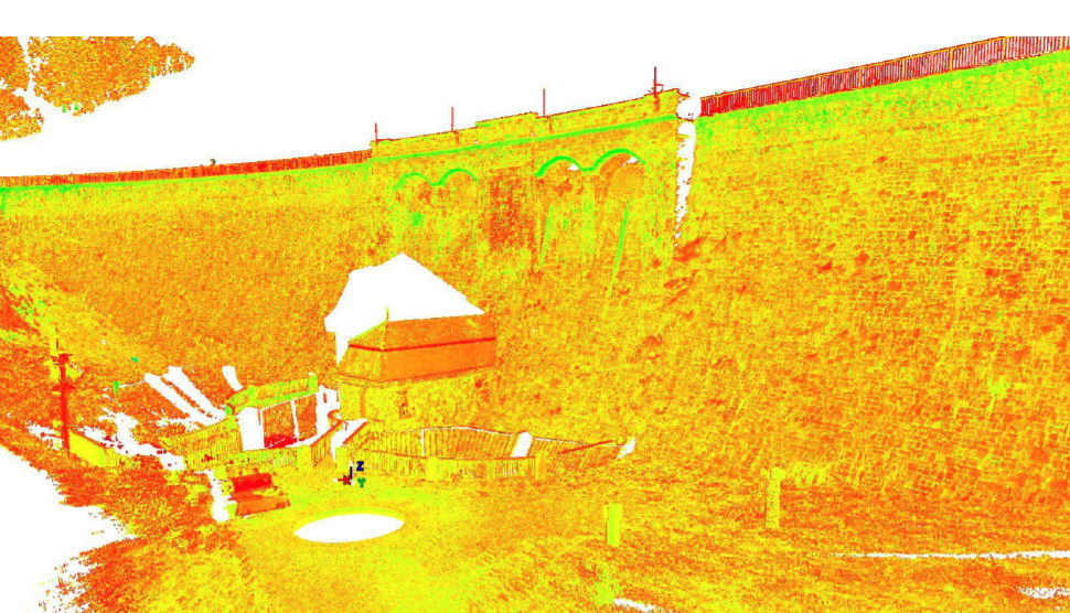
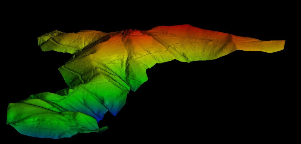 Pointcloud with colouring (altitude levels)
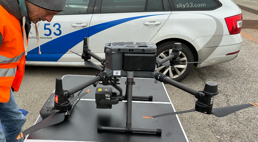
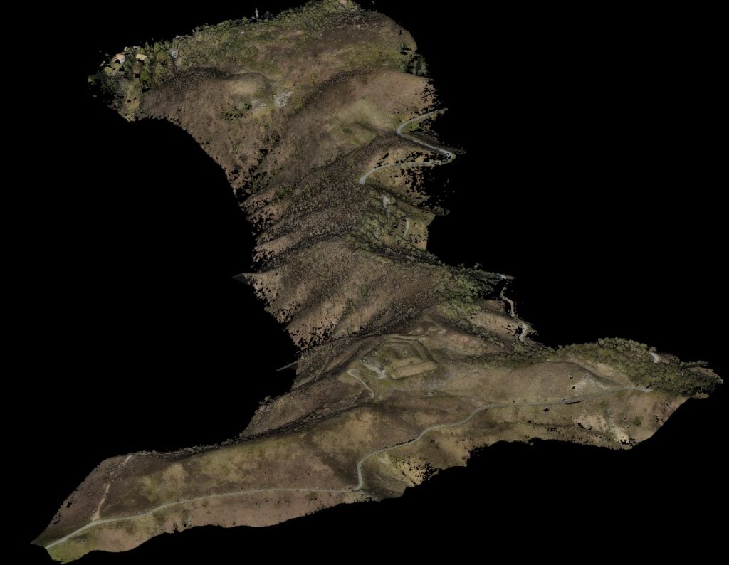
UAV with LIDAR
1. Overview of Point Cloud Acquisition Technologies
1.1 Terrestrial and Aerial LiDAR
Terrestrial LiDAR: Uses laser pulses emitted from a ground-based device to measure distances to objects. Provides high-precision data with a range that can vary from a few meters to hundreds of meters. It is ideal for mapping small areas with very fine details.
Aerial LiDAR: Mounted on aircraft or drones, this system can quickly cover large areas. Although the precision is lower than terrestrial LiDAR, its ability to penetrate vegetation makes it particularly useful for mapping wooded areas.
1.2 Drone Photogrammetry
For example, embankments are a critical element for land safety, especially in a geologically complex country like Italy. Their monitoring is fundamental to prevent landslides and landslips, but traditionally it has always required long timescales, high costs and often the exposure of operators to considerable risks. Today, thanks to the use of drones and advanced surveying technologies, we are witnessing a real revolution in this field.
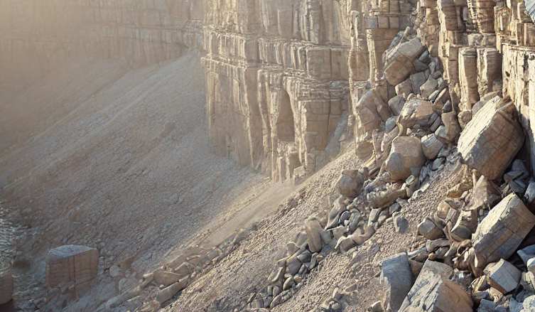
Example of extreme situations to be analysed with UAVs
Drone photogrammetry uses overlapping images to reconstruct three-dimensional models of the terrain. It is a versatile and relatively inexpensive technique that offers good accuracy for geological and geotechnical applications. Drones can reach inaccessible areas and collect data quickly, making them ideal for monitoring landslides and other ground deformations.
 1.3 Terrestrial Laser Scanners
Terrestrial laser scanners can be divided into time-of-flight scanners and phase-shift scanners. The former measure the time taken by a laser pulse to return to the sensor, while the latter measure the phase shift between the emitted and received signals. Both offer high precision and are used for detailed mapping of rock surfaces and geological structures.
2. Fundamentals of Point Clouds
 2.1 Structure of Point Cloud Data
Point clouds are sets of three-dimensional points characterized by XYZ coordinates and additional attributes such as intensity, color (RGB), and classification. These data can be used to create digital terrain models, identify geological structures, and monitor deformations over time.
2.2 Common File Formats
Common file formats for point clouds include LAS/LAZ, E57, ASCII (XYZ, PTS), and PLY/OBJ. Each format has specific features that make it more suitable for certain applications. For example, LAS/LAZ files are widely used for LiDAR data due to their ability to handle large volumes of data with complex attributes.
2.3 Reference Systems and Georeferencing
Georeferencing point clouds is crucial for integration with other geospatial data. Cloud Compare offers tools for coordinate transformation between global (such as WGS84) and local reference systems, ensuring that the data are correctly aligned and ready for analysis.
3. Importing and Preparing Data in Cloud Compare
3.1 Import Process
The import process in Cloud Compare involves managing large files and applying advanced options to ensure that all relevant data are preserved and correctly interpreted. This includes choosing the file format, managing attributes, and optimizing system resources.
3.2 Point Cloud Preprocessing
Preprocessing includes noise filtering, outlier removal, and data downsampling to reduce point density without losing critical information. These steps are essential for improving data quality and preparing them for subsequent analyses.
3.3 Registration of Multiple Scans
Registering multiple scans allows for the creation of a consistent three-dimensional model from various acquisitions. This process includes manual and automatic scan alignment, alignment refinement, and evaluation of registration quality.
4. Section Extraction Methods
4.1 Cutting Plane Method (Cross Section Tool)
The cutting plane method allows for the extraction of two-dimensional sections from three-dimensional point clouds. This tool is used to analyze the internal structure of rock formations, study terrain morphology, and evaluate specific geological features.
4.2 Polyline Method (Extract Sections/Unfold)
This method allows for the creation of longitudinal profiles and cross sections using guide polylines. It is particularly useful for analyzing complex geological structures, such as folds and faults, and for generating high-resolution sections.
4.3 Advanced Extraction Techniques
Advanced techniques include using meshes as reference surfaces, extracting curved sections, and sections with variable orientation. These techniques allow for adapting section extraction to complex geological geometries, improving representation and analysis of rock formations.
5. Processing and Analysis of Sections
5.1 Contour and Profile Generation
Contour and profile generation allows for extracting significant two-dimensional information from three-dimensional datasets. This process includes data interpolation, managing discontinuities and voids in the data, and applying smoothing and simplification algorithms.
5.2 Calculation of Geometric Parameters
The calculation of geometric parameters, such as slope, orientation, curvature, and roughness, provides quantitative information on the morphology and properties of geological formations. These parameters are crucial for slope stability analysis, geological characterization, and structural analysis.
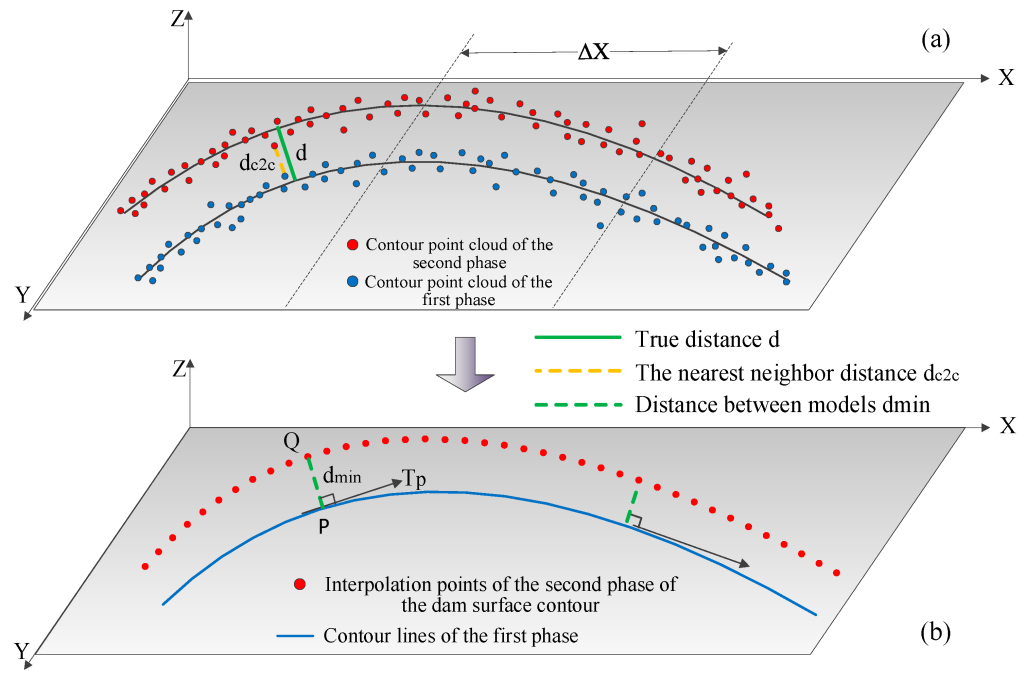
5.3 Temporal Comparison of Sections
Temporal comparison of sections allows for evaluating changes in geological formations over time. This includes multi-temporal analysis, quantification of displacements and deformations, and integration with geotechnical and geophysical data for a complete and accurate analysis.
6. Geological and Geotechnical Applications
6.1 Slope Stability Analysis
Slope stability analysis is fundamental for assessing the risks associated with landslides and mass movements. Using point clouds allows for creating detailed three-dimensional models, identifying potential slip surfaces, and monitoring movements over time.
6.2 Geological Characterization
Geological characterization using point clouds allows for mapping discontinuities, fractures, and geological structures in great detail. This technique is useful for lithology analysis, fold and fault mapping, and depositional environment reconstruction.
6.3 Deformation and Movement Monitoring
Deformation and movement monitoring uses point clouds to detect and quantify changes in terrain and geological structures over time. This is crucial for geological risk management, geotechnical engineering, and the study of geodynamic processes.
6.4 Applications in Geotechnical Engineering
Applications in geotechnical engineering include designing support structures, slope stability analysis, quarry and mine management, and coastal engineering. Using point clouds allows for obtaining high-resolution three-dimensional models, improving analysis accuracy and intervention safety.
7. Export and Integration with Other Software
7.1 Export Formats
Common export formats include DXF for CAD, Shapefile for GIS, and raster formats for digital terrain modeling. The choice of format depends on the specific application and the requirements of the destination software.
7.2 Integration with GIS and Modeling Software
Integration with GIS and modeling software allows for combining point clouds with other geospatial data for a more comprehensive analysis. This includes integration with software such as ArcGIS, QGIS, AutoCAD, and geotechnical modeling software like GeoStudio and PLAXIS.
7.3 Examples of Integrated Workflows
Integrated workflows can include combining LiDAR and photogrammetric data for digital terrain model creation, using point clouds for slope stability analysis in geotechnical modeling software, and integrating with geophysical data for multi-disciplinary analysis.
Practical Case Study: Deformation Analysis of a Water Dam Using Point Clouds
Introduction
Deformation analysis with point clouds is a crucial method in geodesy for monitoring structural and environmental changes. This technique involves capturing and comparing 3D spatial data over time to detect deformations. One practical application of this method is the monitoring of a water dam, which we will explore in this case study.
Aim of Deformation Analysis
The primary objective of deformation analysis is to identify and quantify geometric changes in structures over time. This is particularly important for large infrastructures like dams, where even small deformations can indicate potential issues. The analysis helps in:
- Damage Prevention: Detecting minor changes early to prevent catastrophic failures.
- Conservation of Evidence: Understanding the forces acting on the structure.
- Forecasting Performance: Predicting future behavior under various conditions.
- Verification of Construction: Ensuring the structure conforms to design specifications.
Methodology
Data Acquisition
Point clouds for the dam are obtained using terrestrial laser scanning (TLS). TLS provides highly accurate 3D data by emitting laser beams and measuring their return time. This method is advantageous because it captures millions of points, creating a detailed representation of the dam’s surface.
Deformation Models
Several deformation models are used to analyze the point cloud data:
- Congruence Model: This model compares the current state of the dam to a previous state without considering the time aspect. It helps determine if there has been any movement.
- Kinematic Model: This model incorporates time, analyzing the changes in the structure’s geometry over different time intervals.
- Static and Dynamic Models: These models consider the forces acting on the dam and its response to these forces, with the dynamic model also incorporating time.
Analysis Approaches
Three main approaches are employed to reveal changes in the point clouds:
- Surface-Based Approach: The entire point cloud is treated as a surface. Corresponding points on the dam’s surface are identified, and their changes are calculated.
- Point-Based Approach: Specific points or features on the dam are tracked over time. This approach reduces the data set to essential points with identifiable features.
- Parameter-Based Approach: The dam is parameterized into geometric shapes like planes or cylinders, and changes in these parameters are monitored.
Case Study: Monitoring a Water Dam
In this case, the water dam is monitored for both rigid body movements (translations and rotations) and shape deformations (expansion, compression, and torsion).
Rigid Body Movement
- Translation: Monitoring shifts in the dam’s position in the X, Y, and Z directions.
- Rotation: Checking for rotations around different axes.
- Subsidence and Settlement: Observing any downward movement due to the removal of mass underground or changes in load.
Shape Deformations
- Expansion and Compression: Measuring changes in length.
- Shear and Deflection: Detecting displacements along cross-sections and deviations from the axis.
- Torsion: Identifying twisting around an axis.
Results and Interpretation
The analysis revealed both minor and significant deformations. The surface-based approach provided a comprehensive view, showing areas of the dam that experienced notable changes. The point-based approach highlighted specific points with the most significant movements, while the parameter-based approach offered a clear understanding of geometric changes.
Conclusion
Deformation analysis using point clouds is an effective method for monitoring large structures like water dams. By employing various models and approaches, it is possible to detect, quantify, and understand deformations, ensuring the structure’s safety and integrity.
The extraction and analysis of sections from point clouds using Cloud Compare offers a powerful tool for geological and geotechnical applications. The ability to obtain detailed three-dimensional models, analyze the morphology and properties of geological formations, and monitor changes over time represents a significant advancement in geological risk management and engineering design. With the advancement of acquisition technologies and integration with advanced software, the use of point clouds will continue to grow, offering new opportunities for research and practical application in the field of geology and geotechnics.
Bibliography:
- Automatic Rock Mass Discontinuity Analysis and Characterization
– This paper discusses the use of 3D point cloud data to analyze rock mass discontinuities, involving methods for semi-automatic clusterization and extraction of discontinuity sets, crucial for geotechnical analysis. - Processing and Analysis of Point Clouds from Laser Scanning in Geotechnics
– An in-depth exploration of techniques used in processing point clouds obtained from laser scanning, specifically for geotechnical applications, focusing on the extraction and interpretation of geological features. - Structural Geology with Point Clouds: Techniques and Applications
– This article covers various methods for using point clouds in structural geology, emphasizing CloudCompare’s capabilities in analyzing and visualizing geological structures. - 3D Point Cloud Analysis for Geotechnical Monitoring
– A study on the application of 3D point clouds for monitoring geotechnical structures, including techniques for detecting and analyzing changes over time using CloudCompare. - CloudCompare and the Analysis of Geological Discontinuities
– This paper focuses on using CloudCompare for the analysis of geological discontinuities, offering insights into the software’s tools and algorithms for extracting significant geological features from point clouds. - Advanced Geostructural Survey Methods Applied to Rock Mass Characterization
– The paper presents advanced methods for surveying and characterizing rock masses using 3D point clouds, highlighting the integration with CloudCompare for detailed analysis. - Extraction of Structural Information from Point Clouds in Geology
– An exploration of methods for extracting structural information from 3D point clouds, with a particular focus on geological applications and the use of CloudCompare. - Deformation Monitoring Using Point Clouds and CloudCompare
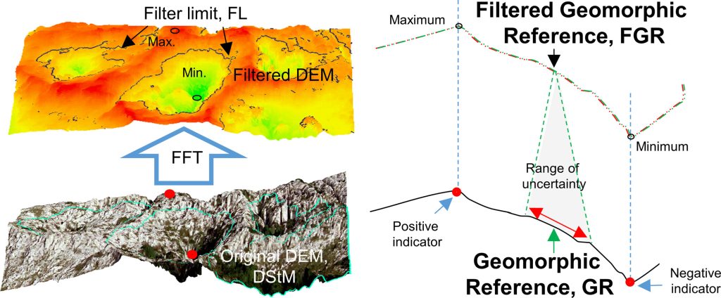
– This article discusses the use of point clouds and CloudCompare for monitoring deformations in geological and geotechnical contexts, providing practical examples and case studies. - The use of filters based on the Fast Fourier Transform applied to DEMs for the objective mapping of karstic features
– Example mapping: The objective mapping of karstic geomorphic features from DEMs using FFT. - A Comparison Method for 3D Laser Point Clouds in Displacement Change Detection for Arch Dams
– Dam deformation monitoring can directly identify the safe operation state of a dam in advance, which plays an important role in dam safety management